Free UK postage
Lancashire 80nw, 6". Edenfield, 1912/1925, black outline, blue geology, red contours. Geological Survey of England & Wales.
Lancashire 80nw, 6". Edenfield, 1912/1925, black outline, blue geology, red contours. In fair to good condition.
Regular price £700 £7.00
Lancashire 73nw, 6". Lydgate, 1912/1925, black outline, red geology, In fair condition. Geological Survey of England & Wales.
Lancashire 73nw, 6". Lydgate, 1912/1925, black outline, red geology, In fair condition.
Lancashire 71nw, 6". Oswaldtwistle, 1912/1925, black outline, red geology, In fair condition. Geological Survey of England & Wales.
Lancashire 71nw, 6". Oswaldtwistle, 1912/1925, black outline, red geology, In fair condition.
Lancashire 70se, 6". Darwen, 1931/1938, black outline, red geology, In fair condition. Geological Survey of England & Wales.
Lancashire 70se, 6". Darwen, 1931/1938, black outline, red geology, In fair condition.
Lancashire 63sw, 6". Rishton, 1912/1925, black outline, blue geology, In fair condition. Geological Survey of England & Wales.
Lancashire 63sw, 6". Rishton, 1912/1925, black outline, blue geology, In fair condition.
Lancashire 62se, 6". Blackburn, 1933/1937, black outline, blue geology, In fair condition. Geological Survey of England & Wales.
Lancashire 62se, 6". Blackburn, 1933/1937, black outline, blue geology, In fair condition.
Derbyshire 35sw, 6". Crich, 1921/1921, black outline, red geology. Geological Survey of England & Wales.
Derbyshire 35sw, 6". Crich, 1921/1921, black outline, red geology. In fair condition.
Derbyshire 35nw, 6". Wessington, 1921/1922, black outline, red geology. Geological Survey of England & Wales.
Derbyshire 35nw, 6". Wessington, 1921/1922, black outline, red geology. In fair condition.
[Geological] Map of the Coal Fields of Durham and Northumberland and Cumberland, 1869, Plate 4, from Mines and Miners; or, Underground Life by L. Simonin
[Geological] Map of the Coal Fields of Durham and Northumberland and Cumberland, 1869, Plate 4, from Mines and Miners; or, Underground Life by L. Simonin. London: Chapman and Hall. Colour...
Regular price £600 £6.00
Yorkshire 274 nw. Cawthorne. Surveyed 1932, issued 1942. Geological Survey of England & Wales.
Yorkshire 274 nw. Cawthorne. Surveyed 1932, issued 1942. Outline geology in black on grey basemap with red contours.Pencil annotations to legend. Water stains and soiled, tape residue on top edge....
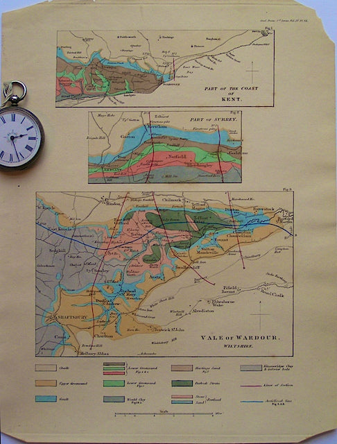
Vale of Wardour, Wiltshire, 1835. TGS.
Vale of Wardour, Wiltshire, 1835, scale 1"=2miles, colour wash, 11"x8.5. Vof W occupies lower half of page; two smaller maps of Nutfield area of Surrey and coast of Kent at...
Regular price £500 £5.00

![[Geological] Map of the Coal Fields of Durham and Northumberland and Cumberland, 1869, Plate 4, from Mines and Miners; or, Underground Life by L. Simonin](http://geolmaps.com/cdn/shop/products/P1080645_{width}x.JPG?v=1551270123)
![[Geological] Map of the Coal Fields of Durham and Northumberland and Cumberland, 1869, Plate 4, from Mines and Miners; or, Underground Life by L. Simonin](http://geolmaps.com/cdn/shop/products/P1080645_580x.JPG?v=1551270123)