Free UK postage
Ireland sheet 11, Londonderry, 1” scale. 1890. First edition. Covers Rathmelton and Buncrana. Base map 1863. Hand-coloured. Geological Survey of Ireland.
Ireland sheet 11, Londonderry, 1” scale. 1890. First edition. Covers Rathmelton and Buncrana. Base map 1863. Hand-coloured engraving, flat, trimmed 41 x 60cm. was cut and joined with cloth tape,...
Regular price £1900 £19.00
Ireland sheet 7, Giant’s Causeway, 1” scale. 1887. 1st ed. Covers Portrush and Ballin. 55% sea. Base map 1865. Hand-coloured. Geological Survey of Ireland.
Ireland sheet 7, Giant’s Causeway, 1” scale. 1887. 1st ed. Covers Portrush and Ballin. 55% sea. Base map 1865. Hand-coloured engraving, flat, 44.5 x 60cm. Old folds worn, split centre...
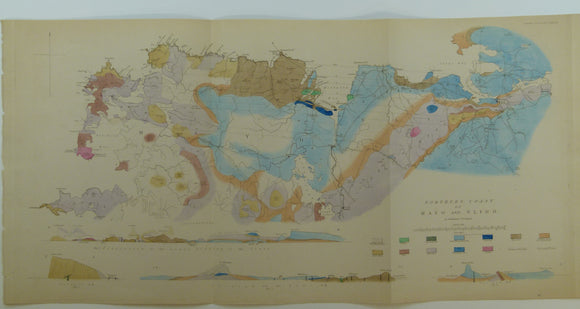
Verschoyle, Archdeacon. (1837). ‘Notices on the Geology of the North Coast of the Counties of Mayo and Sligo in Ireland’. Geological Society of London.
Verschoyle, Archdeacon. (1837). ‘Notices on the Geology of the North Coast of the Counties of Mayo and Sligo in Ireland’ extract from Transactions of the Geological Society. v.V. 2nd Series, pp. 149-170...
Regular price £1800 £18.00
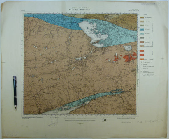
Killarney & Kenmare District, (1913). First edition. Colour print, flat, 56 x 68.5cm. Scale 1:63,360. Base map 1910. Geological Survey of Ireland.
Killarney & Kenmare District, (1913). First edition. Colour print, flat, 56 x 68.5cm. Scale 1:63,360. Base map 1910. Published by OS, 1922. Parts of one inch maps 173 and 184....
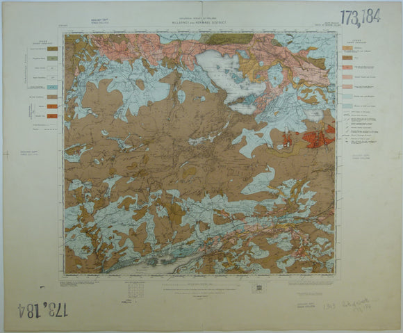
Killarney & Kenmare District, Drift, (1913). First edition. Colour print, flat, 56 x 68.5cm. Scale 1:63,360. Base map 1910. Geological Survey of Ireland.
Killarney & Kenmare District, Drift, (1913). First edition. Colour print, flat, 56 x 68.5cm. Scale 1:63,360. Base map 1910. Published by OS, 1922. Parts of one inch maps 173 and...
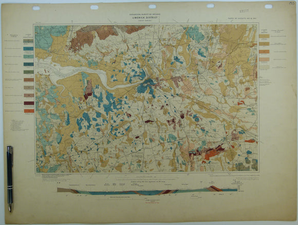
Limerick District, Drift, (1904). First edition. Colour print, flat, 46 x 60.5cm. Scale 1:63,360. Base map 1899. Geological Survey of Ireland.
Limerick District, Drift, (1904). First edition. Colour print, flat, 46 x 60.5cm. Scale 1:63,360. Base map 1899. Published by OS, 1906. Parts of one inch maps 143 and 144. Horizontal...
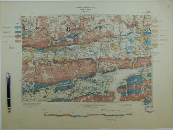
Cork District, Drift, (1903). First edition. Colour print, flat, 45 x 60.5cm. Scale 1:63,360. Base map 1899. Geological Survey of Ireland.
Cork District, Drift, (1903). First edition. Colour print, flat, 45 x 60.5cm. Scale 1:63,360. Base map 1899. Published by OS, 1905. Parts of one inch maps 186, 187, 194 and...
Belfast District, Drift, (1901). First edition. Colour print, flat, 45 x 61cm. Scale 1:63,360. Base map 1903. Geological Survey of Ireland.
Belfast District, Drift, (1901). First edition. Colour print, flat, 45 x 61cm. Scale 1:63,360. Base map 1903. Published by OS, 1904. Parts of one inch maps 28, 29, 36 and...
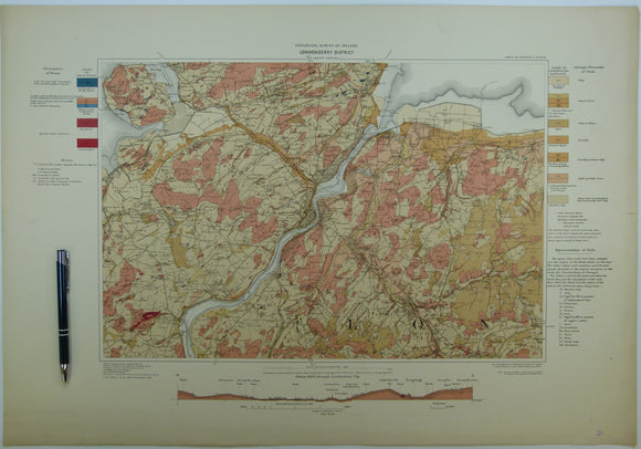
Londonderry District, Drift, (1908). First edition. Colour print, flat, 46 x 66cm. Scale 1:63,360. Geological Survey of Ireland.
Londonderry District, Drift, (1908). First edition. Colour print, flat, 46 x 66cm. Scale 1:63,360. Base map 1899. Published by OS, 1908. Parts of one inch maps 11, 12, 17 and...
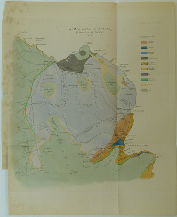
Bryce, James. (1837). ‘On the Geological Structure of the North-eastern Part of the County of Antrim’. Geological Society of London.
Bryce, James. (1837). ‘On the Geological Structure of the North-eastern Part of the County of Antrim’ extract from Transactions of the Geological Society2nd Series, pp. 69-81+ hand-coloured engraved fold out map. Slight...
Regular price £1600 £16.00
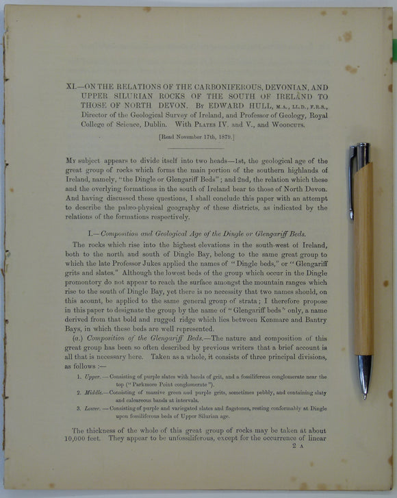
Hull, Edmund. (1879). ‘On the Relations of the Carboniferous, Devonian and Upper Silurian Rocks of the South of Ireland to those of North Devon’, an extract. Royal Dublin Society.
Hull, Edmund. (1879). ‘On the Relations of the Carboniferous, Devonian and Upper Silurian Rocks of the South of Ireland to those of North Devon’, an extract from the Scientific Transactions...
Regular price £1400 £14.00
Gardiner, C.I., and Reynolds, S.H. (1912). ‘Geological Map of the Kilbride Peninsula (Mayo)’ [Ireland] in ‘The Ordovician and Silurian Rocks of the Kilbride Peninsula (Mayo)’, extract. Geological Society of London.
Gardiner, C.I., and Reynolds, S.H. (1912). ‘Geological Map of the Kilbride Peninsula (Mayo)’ [Ireland] in ‘The Ordovician and Silurian Rocks of the Kilbride Peninsula (Mayo)’, extract from the Quarterly Journal...
Gardiner, C.I. (1914). ‘Geological Map of the Lough Nafooey Area’ [Ireland] in ‘The Ordovician and Silurian Rocks of the Lough Nafooey Area (County Galway)’, extract. Geological Society of London.
Gardiner, C.I. (1914). ‘Geological Map of the Lough Nafooey Area’ [Ireland] in ‘The Ordovician and Silurian Rocks of the Lough Nafooey Area (County Galway)’, extract from the Quarterly Journal of...
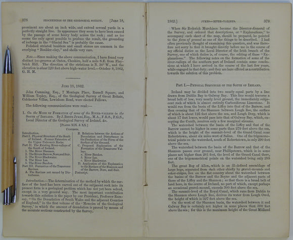
Beete Jukes, J. (1862). ‘Geological Map of parts of the Counties of Cork and Waterford’ in ‘On the Mode of Formation of the River Valleys in the South of Ireland’ extract. Geological Society of London.
Beete Jukes, J. (1862). ‘Geological Map of parts of the Counties of Cork and Waterford’ in ‘On the Mode of Formation of the River Valleys in the South of Ireland’...
Section No. 3 (1860). Covers Maryborough, Castlecomer Coalfield, Barrow valley, Bagnalstown. Hand-coloured engraving, iIllustrates maps 127, 128, 137 & 147. Geological Survey of Ireland.
Section No. 3 (1860). A continuous section from the Limestone Plateau between Abbeyliex and Maryborough, over Cullenagh Hill, and thence south-eastwards across the Castlecomer Coalfield to the Valley of the...
Ireland sheet 151, Listowel, 1” scale. 1881. Includes mouth of the Shannon, south side. Base map not dated. Hand-coloured. Geological Survey of Ireland.
Ireland sheet 151, Listowel, 1” scale. 1881. Includes mouth of the Shannon, south side. Base map not dated. Hand-coloured engraving, flat, linen-backed, trimmed 36 x 51cm. Faded colours, soiled, age-toned,...
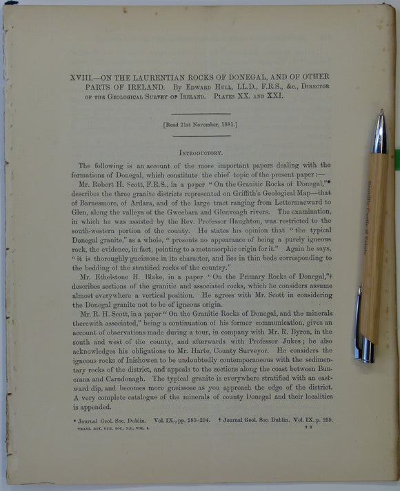
Hull, Edmund. (1881). ‘On the Laurentian rocks of Donegal, and of other Parts of Ireland’, an extract from the Scientific Transactions of the Royal Dublin Society,. Royal Dublin Society.
Hull, Edmund. (1881). ‘On the Laurentian rocks of Donegal, and of other Parts of Ireland’, an extract from the Scientific Transactions of the Royal Dublin Society, v.1ns, pp.243-256. Includes colour...
Regular price £1200 £12.00
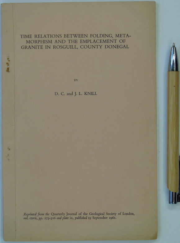
Knill, D.C., and J.L.. (1961). ‘The Geology of the Rosguill Peninsula, Co. Donegal, Eire’, in ‘ Time Relations between Folding, Metamorphism and the Emplacement of Granite. Geological Society of London.
Knill, D.C., and J.L.. (1961). ‘The Geology of the Rosguill Peninsula, Co. Donegal, Eire’, in ‘ Time Relations between Folding, Metamorphism and the Emplacement of Granite in Rosguill, County Donegal’,...
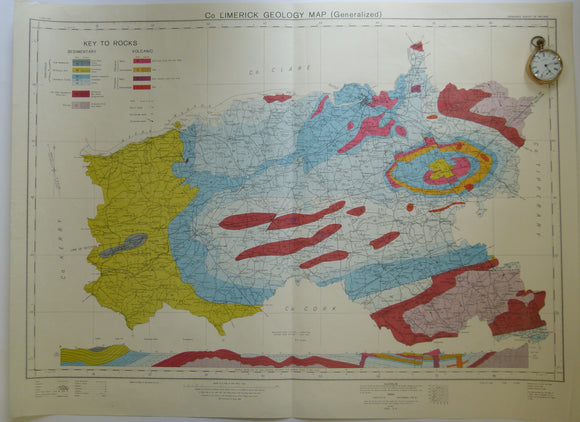
Glacial Drift Map of Co. Limerick Geology Map. 1966. Geological Survey of Ireland. Geological Survey of Ireland.
Glacial Drift Map of Co. Limerick Geology Map (Generalized). 1966. Geological Survey of Ireland, based on surveys of 1959-61. Scale 1:126,720. 50.5 x 67 cm. Colour printed. Clean, bright. In...
Co. Limerick Geology Map. 1969. Ordnance Survey of Ireland. Geological Survey of Ireland.
Co. Limerick Geology Map (Generalized). 1969. Ordnance Survey of Ireland, based on maps of Geological Survey. Revised to 1964 with railways revised to 1967. Scale 1:126,720. 57.5 x 78 cm....


![Gardiner, C.I., and Reynolds, S.H. (1912). ‘Geological Map of the Kilbride Peninsula (Mayo)’ [Ireland] in ‘The Ordovician and Silurian Rocks of the Kilbride Peninsula (Mayo)’, extract](http://geolmaps.com/cdn/shop/files/Kilbride_2_{width}x.jpg?v=1705423613)
![Gardiner, C.I., and Reynolds, S.H. (1912). ‘Geological Map of the Kilbride Peninsula (Mayo)’ [Ireland] in ‘The Ordovician and Silurian Rocks of the Kilbride Peninsula (Mayo)’, extract](http://geolmaps.com/cdn/shop/files/Kilbride_2_580x.jpg?v=1705423613)
![Gardiner, C.I. (1914). ‘Geological Map of the Lough Nafooey Area’ [Ireland] in ‘The Ordovician and Silurian Rocks of the Lough Nafooey Area (County Galway)’, extract](http://geolmaps.com/cdn/shop/files/Nafooey_1_{width}x.jpg?v=1705423421)
![Gardiner, C.I. (1914). ‘Geological Map of the Lough Nafooey Area’ [Ireland] in ‘The Ordovician and Silurian Rocks of the Lough Nafooey Area (County Galway)’, extract](http://geolmaps.com/cdn/shop/files/Nafooey_1_580x.jpg?v=1705423421)